Day 8: Chora Sfakion – Souda

Total distance: 24.51 km
Average speed: 5.52 km/h
Total time: 06:22:00
Download file: Kayak-ChoraSfakion-SoudaPlakias-Short110718.gpx


Today we start all together, a short family trip. We drive to Chora Sfakion and it takes a while. The kayak is still there after a couple of nights.
By the time I set off it’s late, it’s noon already! It’s also pretty hot, the water too!

Right away I see some caves, including one with an open ceiling which I visit. I don’t want to rush it too much today. I pass between some rocks, then I see some small nice beaches and clear waters. Around a rocky outcrop, I see Filaki, that is Prison beach, which looks especially good. I jump in for a swim, but I don’t push myself hard enough off the kayak and hit the side with my shin. I get a big bruise and deep wound as a result. I can see the white bone underneath! I abandon the swimming pretty soon. I resume paddling. It’s painful.

Luckily the coastline is pretty interesting here, lots of little caves. I have been able to see Frangokastelo, my midday stop, for a while. After the last caves I aim straight for it. The waves have grown now, and I see plenty crashing on shallow rocks near a harbour. I know there’s a beach on the other side which is sheltered. I try to find a passage through the really shallow rocks and ride some fun waves. Then I turn back and go all the way around. I land and we have lunch all together on the windy side, in the shade of our beach tent.

I snooze a bit after a lunch, at this point I am not super pumped at the idea of paddling again. The wound burns and it’s hot. I get in the kayak and just go. I need to cool down, I go in for a swim, it feels better. I see a series of pretty beaches, worth a visit. The place looks good for snorkelling too. I see some fishing nets, always a good sign.

It’s not long before I am in Korakas, where I am meeting the family. The water is actually less nice there. I decide on the spot I can keep going a bit further, after a little snack of a few biscuits. So on I go, along an eroded stretch of coast. Till I get to an interesting tall rocky outcrop, around which I see Plakias. Meeting point is in Souda though, the beach before.

I meet the last challenge of the day just before Souda. I can see big ripples in front in an otherwise completely flat sea. There is some freak wind blowing offshore, it’s really strong and goes in gusts. Maybe the famous katabatic wind? Whatever it is, it’s powerful and I have to be very careful to keep balance and put all my energy into this last crossing. As I approach Souda beach, it blows against me, so the last few hundred metres I am paddling into it. At last I make it to shore, and park the kayak next to a pedal boat. We rent a room and have dinner in Plakias, a proper tourist resort, not worth a second visit!

Day 7: Agia Roumeli – Chora Sfakion

Total distance: 17.72 km
Average speed: 5.74 km/h
Total time: 03:30:07
Download file: Kayak-AgiaRoumeli-ChoraSfakion-Short090718.gpx


The night was in fact so hot that I opted for falling asleep with the AC on, something I don’t recall ever having done before.
I am sleepy when the alarm goes off, and I force down some buiscuits despite the total absence of appetite. I’m probably still full from the big dinner last night.

It looks like a good day, calm, hot. The forecast shows smaller waves. I feel a bit more experienced anyway, after yesterday. I was land-sick all evening! My arm and shoulders muscles show signs of fatigue. I have paddled for like 2 minutes when I start feeling tired. I understand it’s not a good sign, but I feel confident because I only have 4 hours to paddle today, and in better conditions.

I watch the exit of the famous Samaria gorge as I set off. Then I paddle along Agios Pavlos, the beach with the church. I see more interesting beaches, with backdrops of gorges, cliffs, steep hills, worth visiting another time. The waves are reasonable, and they’re behind me. I just paddle and paddle for a while, singing along.

There’s a long stretch of barren, lower rocky coast now. The water is shallow, so I jump in for a snorkel. Waves are rocking me a bit, and it’s less interesting than I thought. I get back on the boat and paddle some more, and I am quickly go around this rounded coastline and spot Finikas and Likos in the distance. I have been there before, and they looked a bit like the deserted island village in the movie ‘Mediterraneo’ when the Italians first land. I don’t get too close this time. I do see Marmara beach, which is at the end of Aradena gorge, and looks gorgeous. I even see a few double kayaks paddle to shore and land there, with some difficulty, though the sea is completely flat on this side.

Past the next cape after Finikas bay, I take a break and eat a few more biscuits, 3-4. I feel a little hungrier now, after over 2 hours of paddling. What I thought was a quiet small bay is actually a place of high boat traffic. I count about a dozen boats speed by in less than 10 minutes. That’s because Loutro is around the corner, and I can see my destination, Chora Sfakion, only a few km away.

I pass right next to Loutro’s rock and watch the village behind me. It looks overdeveloped for such a small place, less attractive than what I have seen so far. I can see someone walking on the path back to Chora, which skirts a small beach. It looks hot out there! The next beach I see is Glyka Nera, Sweet Waters. It has a good number of sunbeds and looks pretty inviting. I am trying to make the 1 o’clock bus though, and I’m running out of time. I don’t fancy spending the whole afternoon in Chora waiting for the evening bus and get home late. So I resist the mermaids and paddle on.

Next are several caves, around Ilingas beach and just before Chora itself. I make a note to come visit them another time. I wonder if they host anything special like monk seals, but the main town is really close now. I have been faster today, I don’t even feel tired anymore. 4 hours are a piece of cake, ha! I land on the smallest beach in Chora Sfakion. Sunbeds, people and a couple of kayaks stored on one side. A guy offers timely and useful help to pull the kayak out of the water. A nice young girl, something like the beach guardian, takes the kayak under her protection and offers to store the paddle separately inside. This is a good welcome. I grab my stuff, get a spinach pie from the bakery and walk straight to the bus stop. The bus is later than scheduled, so I have time to eat my lunch in the pines shade. The wind is blowing, another day is done, all is good.

Day 6: Paleochora – Agia Roumeli

Total distance: 27.61 km
Average speed: 5.19 km/h
Total time: 07:10:05
Download file: Kayak-Paleochora-AgiaRoumeli-Short080718.gpx


Today has a sudden start.
My alarm is set so I have time to catch the bus to Paleochora, but as it happens, it’s Sunday and I don’t realize that the alarm is only set for weekdays. So at 8am Fiona wakes me up in a rush, the bus is in 20 minutes! Luckily all my stuff is ready, and I will have breakfast while waiting for the bus connection in Tavronitis.

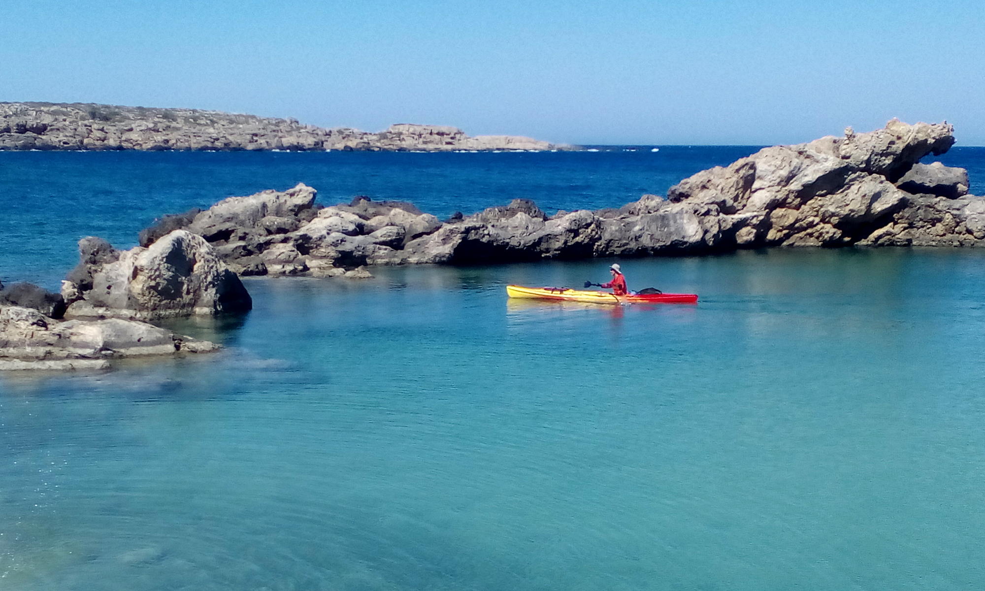
During the bus ride I have time to wake up properly. I get to Paleochora with my many sacks and walk from the bus stop to the beach. I am already sweating, it’s almost 11am, there is no wind. I load two extra bags on the boat, the sleeping bag in the front hatch and the tent and mat in the back open sink. And off I go, on a 2-day paddle that should take me all the way to Chora Sfakion.

It’s a smooth start, the air is still and the day so hot that I need to jump in the water as I start paddling to cool down. I have a long way to go today, about 27km according to the plan.

I pass Anydri beach, where the same name gorge runs down to the sea. The waves are getting bigger, and I am starting to realize that maybe the forecast which had 1.5m waves was right after all. By the time I reach the cape, I am rocked by waves that are definitely taller than me on the boat, and by a good measure. So I get a little worried. I look ahead, breathe, and calm myself down, I am here to enjoy it, it will be fine.

Around the first cape it’s somewhat sheltered and the waves are smaller. I have time to take a look at a cave and at the scenery around. Before long I turn around another cape that takes me into Lissos bay, and the sea gets suddenly really flat. I can now paddle very close to the rocks, and then I jump in for a swim. The water is cool. There are quite a few boats around Lissos, the first ones I have met in almost two hours of paddling. I check the time and I realize that I have been pretty slow, because of the waves and some head wind I met before the Paleochora bay East cape. I decide to press on and get to Sougia for lunch.

Sougia is a nice, small village on the South coast, on the E4 and South-West ferry routes, known also for being free-camping friendly. The beach is sheltered from the big waves today, and the coarse, dark sand is really hot. I land the kayak on the West side and go straight for some shade under the tamarisk trees with my fish sandwiches and fruit. I take a good hour break, enjoying the gentle, warm breeze.

By the time I restart, it’s well past 3pm. I feel a bit energized by lunch, but soon I face big waves again. I see a church on a beach, Agios Antonios. As I go past it, I am rocked by waves that I estimate certainly higher than 1m, and will later get up to 1.5m. I spot some people on the rugged coastline, near a raised cave. Are they waiting for something? A boat taxi appears behind me and picks them up.

I see little caves along the coast. Then a Greek flag on a rock. I am feeling a little sea-sick, am I hallucinating? I soon understand it marks the exit to Tripiti gorge. It looks impressive, but I’m in no shape to take a closer look. I march on. Sedoni beach looks very nice, it has some people on it with a rental boat, and it’s facing the right side, away from the waves. Another long beach ahead, Domata. Looks also good, I am firmly aiming for the cape now, which looks within reach. It’s a profile of a crocodile, as Bob Tait had pointed out to me.

Bob has lived in Paleochora for a long time and has explored a lot of the area, both the sea by kayak and the land on foot. He had warned me that around this area the sea could get choppy. I certainly wasn’t expecting waves twice my height when I set off in the morning though! To add to the atmosphere, the sea suddenly changes colour around cape crocodile, going from dark blue to murky turquoise. It’s disorienting. Waves are at their highest point, and come from every direction. They come from North-West and bounce all over the place. It’s almost fun. I’m tired, and relieved to see more boats.

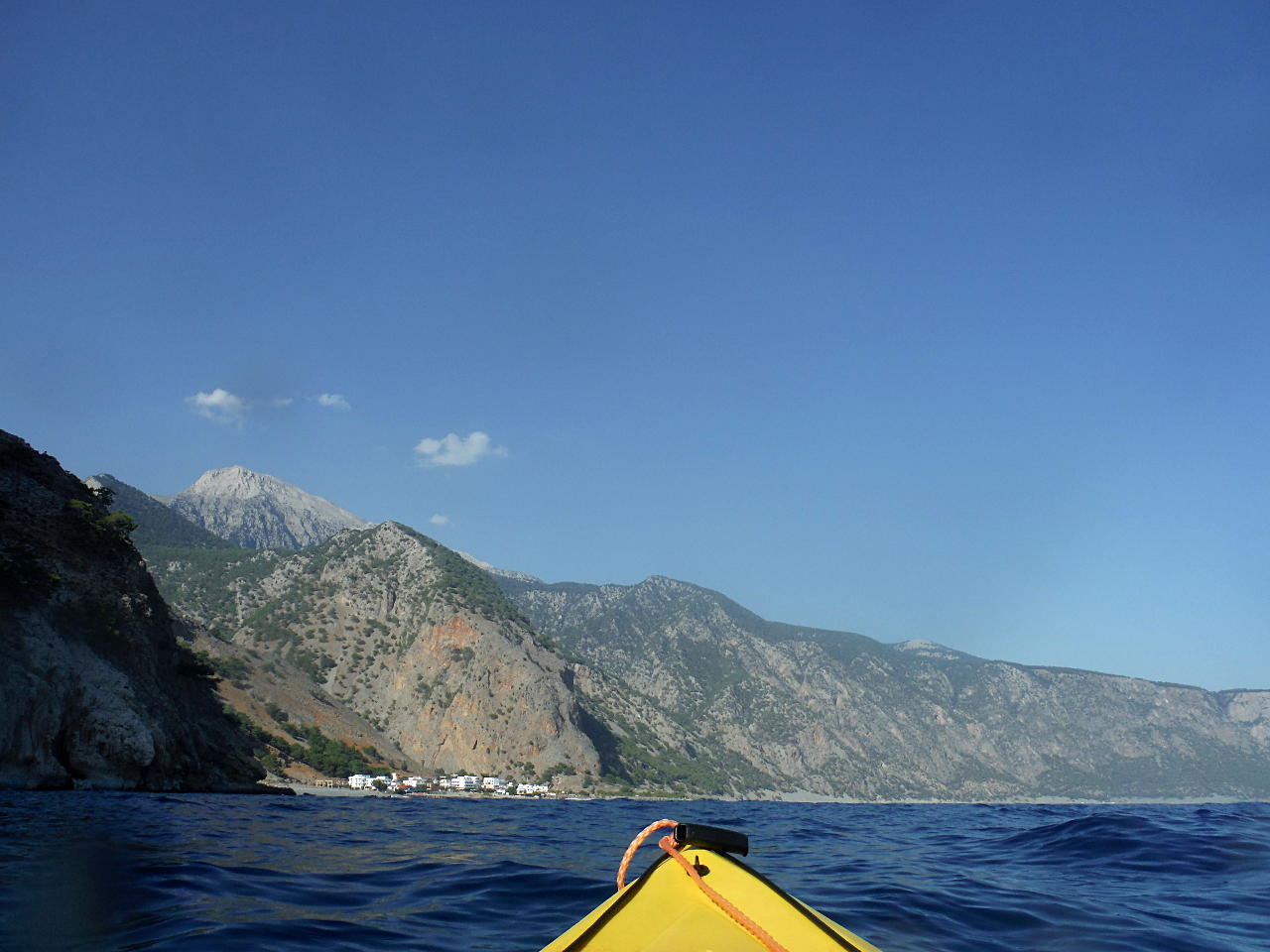
As I turn around the cape, I am confused because I thought I would be able to see Agia Roumeli, but I see what looks like a single building in the distance. I check the GPS, and realize that I was wrong, Agia Roumeli will not be visible for a while, and later I understand that the building I can see is Agios Pavlos.

I see some little beaches facing East, almost completely in the late afternoon shade. The sea is easier now. Families with small boats populate these beaches. Some have caves. They look interesting. It’s comforting to see humans. Agia Roumeli comes into sight at last. I watch the last ferry of the day load a horde of day-hikers from Samaria gorge and leave for another town connected to the road network. When I am close enough, I jump in and swim to shore. After about 6 hours of paddling, the last 3 basically without break, it’s a good change. If I didn’t have a preference for avoiding drama, I would probably kiss the land. Fatigue makes it very hard to pull the kayak up the shore. It’s still very hot in Agia Roumeli, not the slightest breeze will be felt throughout the evening and the night. Still, I take an instant liking to this place. All the world’s worries feel very distant after the departure of the last ferry. I get a room for the night from the first place I see, keen to get some food. After a brief walk around the village, I close the day with an excellent dinner at the Kalypso taverna. I think I must come back here some time, without any mission, just to look around and visit some bits of beaches and gorges I have only taken a glimpse of today.

Day 5: Elafonissi – Paleochora

Total distance: 18.39 km
Average speed: 5.72 km/h
Total time: 03:56:35
Download file: Kayak-Elafonissi-Paleochora-Short060718.gpx


Today I am properly starting the journey around the South coast.

I took a break of a couple of days and developed a weird pain in the palm of my left hand, probably the result of the ‘grip of death’ in the last two days of kayaking. Also some strong back pain. Today I feel less sorry for myself and generally good.

There is already a queue of cars driving to Elafonissi before 9am. When we get there, the watersports instructor I left the boat with is initially less than impressed, then we talk about the wind and he mellows out.

The day is beautiful, the light is stunning. I set off at an easy pace towards Kendrodassos, the Juniper Forest. I stay inside the bay and go from little wind to dead calm. I aim for a sandy beach in the middle of the bay. There is some foam and junk floating not far from the shore, so I wait to jump in until I get to the next two little beaches, still inside the bay.

Now the waves are coming in, nothing big but they do rock the boat. I dive in to snorkel. Plenty of fish! I am uncomfortably close to the rocks though, so I don’t stay in very long. I get on and start paddling again. Jetskis appear from around the cape. I have left the bay and now admire the vertical rocks, at the same time watching the shallow rocks in the water. I quickly get to Viena, with a sheltered bay and a perfect natural lake. There’s a family snorkelling around. I see the remains of the ancient temple. I land on the tiny beach and have a snack, just a short break. I am still at the start and I want to get on.

Leaving Viena, I jump in the water for another snorkel. I am towing the kayak along, but I don’t see much. It’s quite deep except very near the shore, and I am wary of getting to close to the rocks, the waves are breaking and not insignificant. In a few minutes I get around to Krios. The sea is completely flat here. I see little blue leaping fish, so I jump in again. I watch them from underwater, and swim by a rock in the middle of the bay while towing the kayak. Then I get on again, and start paddling.

I can see Paleochora in the distance, I estimate about 2 hours to get there. This part is boring, so I just paddle and paddle. Sometimes I put my hands in the water and splash myself, sometimes I jump in the water for a proper cool down. Past Grammeno cape I take a break and eat some food. Less than half a sandwich. I still have quite some way to go and I want to make the 3:30 bus, it’s already past 1pm.

I am paddling in a completely still zone, but just South of me, maybe a couple hundred metres on the right, I see white horses, so the wind is out there, it just doesn’t get near the coast. It’s a strange effect to look at. I soon take a straight line for the point between Paleochora harbour and the big rock with the lighthouse. I pass between the two and turn around towards East beach.

The beach has big pebbles. As soon as I land, a guy with a racing bike on the beach comes to chat. Giorgos speaks Italian, lives in the UK and clearly we like similar things. It’s too hot to cycle, he admits, it’s about 39°C! But he’s got a new double kayak that he’s keen to take out soon. Unfortunately, I don’t think our schedules meet, no paddling together this time. Giorgos helps me carry the kayak to a restaurant parking lot across the road. Then I sit and have a beer, while I’m waiting for the bus. I eat the rest of my sandwich before crossing the island from South to North in an hour.

Day 4: Voulolimni – Elafonissi

Total distance: 9.21 km
Average speed: 6.17 km/h
Total time: 01:43:36
Download file: Kayak-Voulolimni-Elafonissi-Short030718.gpx


Today I am finishing what I had planned to do yesterday, get to Elafonissi.
The forecast is not much different, but the plan is. I am going to beat the wind on time, as I have seen it pick up only mid-morning.

After a relatively early rise, I set off from Voulolimni confident that I have time to get out before the serious wind, and it’s less than two hours paddling anyway.

The plan works.
I pass the monastery of the Golden Step quickly. I take a brief look at Asprolimni, White Lake, another circular lagoon which doesn’t have a good entrance for my boat though. I watch the Theophrastus palm tree from a distance. These palm trees are the only European palm trees, they famously grow on Vai beach on the other side of Crete, on the East coast, but there is a very small patch of them also here.

There is little wind, and some wave pushing me from behind. Past the harbour, I get to the shallow rocks and navigate through them for some fun. Then around the low outcrop, and Elafonissi comes into view. It’s smooth paddling, I’m just taking it easy.

I go around the peninsula of Elafonissi, have a close look at the church and lighthouse. More shallow rocks, and when I turn around on the East sheltered side, the water is completely flat and clear, though the wind is still blowing.

It’s a hot day. The sandy coves are filling up with people, seeking cooling respite in the chilly water. I spot family! We take some pictures on the pink sand. Giulia and Sofia join me on the kayak and we paddle together to the shore.

An easy, quick, good day.

Day 3: Sfinari – Voulolimni

Total distance: 15.42 km
Average speed: 6.23 km/h
Total time: 03:14:15
Download file: Kayak-Sfinari-Voulolimni-Short020718.gpx


A few days of serious West wind forced me to have a break. I didn’t fancy kayaking in 2m high waves. On the other hand, we had some fun playing in the big waves in Falasarna.
Today the forecast is 4 Beaufort, but at least it should be coming from North-East.

In the morning we drive to Sfinari. It’s still quiet around the Sunset taverna. Some partridges wander freely around. The sheperd is milking the goats. It’s already past 10 o’clock though by the time I set off, and the breeze is turning into a proper wind. I paddle along the coast to Cape Crow. As soon as I turn around it, the waves get serious. They are pushing me from behind at an angle, and I struggle to keep my course. I glance at the beautiful beach at the end of Kampos gorge, and I keep going.
I paddle by Afratolakkos beach, the water is flatter just around the cape and beautifully clear. I take a fairly straight line to a point a little bit before the end of the bay. The waves are quite serious now. I look for Xotikospilio, a deep, famous cave just behind the beach. In the 19th century, during Crete’s fight against the Ottomans, a group of locals sought shelter there, but were eventually found and killed. There are many similar episodes all around Crete, still remembered and commemorated today. I have visited the cave before, but I can’t see it today, the entrance is well hidden.

I ride the waves into Keramoti bay. I take a sharp turn looking for a little shelter, the wind finds ways around the rocks though and pushes me around. I aim again for the end of the bay, keeping a safe distance from the shore. I watch all the new luxury villas recently built or under construction along this wild stretch of coast. The coastline has much lower relief now, I am in Livadia. I remember the shallow rocks in the water and the little kiosk on the corner, where the coastal road turns up inland.

More flattish bits, greenhouses, straight roads. I paddle and paddle, the wind is changing. Some moments of confusion follow, where is it coming from now? It’s not pushing me from behind any longer, but it’s not coming from the side either. It feels like it’s in my face! The North-East has turned into a South-West. I am also having a hard time reading the geography of the coastline, not sure where I’m supposed to aim at. Are those low rocks the next point? Or that taller cliff? The mystery takes a while to clear up. I need to go around the shallow rocks, then paddle some more to get to Stomio. I must be tired.

Into Stomio bay, a quick peek at the remains of the quarry, then straight for the next point. I can see the monastery of Chrisoskalitissa now. Before getting out of the bay, I take a little tour of a well sheltered pool between the rocks. It’s so peaceful inside. Outside it’s blowing hard, I think it’s coming from West or North-West now, it keeps changing.

I’m tired, it’s been two hours and a half without any proper break. I go for my scheduled stop, Voulolimni, a perfectly circular natural coast lake, aurrounded by rocks with only a small, practically invisible entrance. Only if you know it you can find it. Again, it’s pretty wild out there, but it’s flat as a lake in here.

I stay on the boat for my break. Eat a small sandwich, force it down really, I’m not hungry. Gulp some water, take a video, ready to restart. I don’t want to miss the bus back and I still have quite some distance to cover. So I get out of this peaceful spot and I’m instantly scared. The sea is now all white, but the greatest shock are the waves, much taller than I remember only half an hour before, and I am still in the bay. The wind has picked up properly. I paddle ahead another 2-3 minutes, but I’m really not convinced, and worried about going around the cape before Elafonissi in these conditions. I know it’s a tricky place, wind-wise and full of shallow rocks. I turn back.

Tired and discouraged, I call Fiona to come and pick me up. She kindly obliges. I have all the time to eat the rest of my lunch, watch a guy rock dive while taking selfies, get some energy and spirit back. Driving home, I agree with my decision though, it does look pretty wild out there, with all the white horses. Better alive than brave!

Day 2: Balos – Sfinari

Total distance: 23.01 km
Average speed: 6.32 km/h
Total time: 04:32:59
Download file: Kayak-Balos-Sfinari-Short250618.gpx


The plan for my second day of kayaking around Crete is to take a lift to Balos and go as far as my arms will take me.

The weather forced me to take a break, I have done this stretch of coast before and I really don’t fancy doing it in wild winds. It’s very exposed and there is no landing for a good two hours. The last time I did it, I also made an important discovery: you can get sea sick when you paddle a kayak. An experience I am not in a hurry to repeat.

So I pick what should be a day of mostly East wind, which I should be sheltered from, and max 3 Beaufort.

The plan works out well. I get a lift on the back of a pick-up truck almost straight away. The Seicento is still being worked on. I scan Balos lagoon from the top before walking down. The sea looks calm, the colours are amazing.

By the time I get down to the beach and put the kayak in the water, the wind has picked up a little. I circle the Pan, the rocky hill on the Balos peninsula. It goes easy, until I turn my back to Balos. On my left, impressive rock formations on the cliffs. Behind me and on my right, waves that seem to come from nowhere.

And so it goes for the first two hours. I paddle and paddle, taken between admiring the cliffs on one side and riding the waves from the other side. The wind is also pushing me.

I feel very fast. I get to Falasarna without any breaks. After turning around the cape, I moor on a rock by the WWII shipwreck, near the entrance to the ancient Falasarna harbour site. The sea is flat here at last, though the wind is pushing me around a bit. I eat my snack and check all equipment. It’s too cold for a swim so I restart.

Across Falasarna bay the waves are not as big. There’s a big, dark cloud on top of Manna, the tallest mountain just above Falasarna. I watch all the beach-goers on the sandy shore from a distance. It’s been an easy morning so far, I keep going around the point, see the continental shelf a few metres underwater.

Past a little church and a beautiful snorkelling spot, inside a very low cave, a slalom between the low rocks. Around the last point at the North entrance of Sfinari bay, I take another break and jump in the water. It’s frozen! I know this part of the coast generally has cold waters, yet I can’t help a gasping reflex when I jump in.

The sea is eerily still now, the sky is completely covered in clouds, it’s pretty dark and the air is heavy. I paddle fast and fly on the still water all the way across to Sfinari. Giulia and Sofia come and meet me in the water.

Another day, another shore.

Day 1: Kissamos – Balos

Total distance: 20.86 km
Average speed: 5.45 km/h
Total time: 04:36:16
Download file: Kayak-Kissamos-Balos-Short210618.gpx


On the longest day of the year, the summer solstice, I embark on this adventure to kayak around the island of Crete.

The day is good, not only for the long amount of daylight available, but also for the sympathetic wind conditions.

I decide to set off in the afternoon, so I can arrive in Balos not long before dusk and enjoy the latest sunset of the year.

My girls come with me to Mavros Molos, the most recognizable beach in Kissamos. It’s 2:30pm, the sky looks good, there is some breeze from the North.

I make straight for the tip of Kissamos harbour’s outer arm. Then I take a very wide, almost asymptotic approach to the long peninsula. The paddling is easy. I meet some fishing boats. I pass by Kakia Skala (Bad Ladder or Landing), full of jagged shallow rocks. I see the huge cave, open to one side, perching on the cliff. I spot the little church at the Northern end of the same bay. It’s been almost two hours, time to take a break. I spot more fishing net buoys, and tie my boat to one of them. The wind gusts are not weak, and I don’t want to drift back! After a snack, I restart very close to the cliffs. As the wind dies down completely, I meet two of the big boats coming back from Balos packed with the day-trippers. I raise and shake my paddle to salute, and dozens of people on the side wave at me at the same moment. That’s a good boost!

As the sun descends, it plays hide and seek behind the tall cliffs on my left, and I shift between light and shade until the cape. There are multiple rocky outcrops before the actual cape, I don’t quite know which is the right one, until the island of Wild Gramvousa comes into sight. Behind it, in the misty distance, a glimpse of Antikythira, 50km away.

I paddle around the cape, where the cliffs become lower while staying vertical. There is no difference in the wind, it’s still very still, but it’s definitely choppy now and there are rebounding waves that make the sea look like it’s been brought to a gentle boil.

More features appear in order: the island of Tame Gramvousa, Mouse Island, and at last Balos lagoon, right ahead. I aim straight for it. My arms are very tired at this point.

When I get close enough, about 1km from the shore, I put my mask on and jump in the water. The temperature is similar to the air outside, but the liquid medium all around my body feels good. I tie the kayak rope around my waist and start swimming slowly. I get distracted by a big shell first, which I dive to pick up. A local fisherman has just finished putting down his net nearby. He comes to me with his little boat, ‘Pirate’, offering me a tow to the shore, which I decline. I restart swimming and I spot a big flat brown circle on the sandy bottom: a ray! Then another one, then some more. I follow them around for a few minutes.

I hear familiar voices. My family is swimming towards me. We have a water reunion. The little girls tow me to the shore. The sun is already low. We eat some sandwiches, hide the kayak in the dunes, make our way up the path to the parking lot. It’s the very last light as we start driving back. John’s old Seicento, which has served us so well for the last 6 months, stops after a few km on the rocky road. It stubbornly refuses to restart. We hitchhike with the very last cars coming back from Balos, two Spanish girls living in Bristol give us a lift home for the end of the day.